
resources
Mental Health and Substance Use Resource Guides
mental health and substance use resource guide
Youth Mental Health Guide Website
Guía de recursos sobre salud mental y consumo de sustancias
local resource guides and sites
mitchell-yancey community resources website
yancey county health department health & wellness resource guide
dementia caregiver resources
for yancey county
summer resource guide
")
Find a variety of fun, family-friendly, free and low-cost summer activities offered throughout Yancey and Mitchell counties! Click below to download the latest Summer Resource Guide.
drug drop locations
![]()
Safely dispose of unused medication at one of 4 permanent drug drop boxes. We encourage you to leave medication in the original prescription bottle for the purpose of identifying the type of medication (please MARK OUT personal information on the label).
Yancey County Sheriff’s Office
Main Entrance
(828) 682-2124
24 hours/ 7 days per week
Burnsville Town Hall
Mon-Fri 8:30am-4:30pm
Mitchell County Sheriff’s Office
Main Entrance
(828) 688-3982
Mon-Fri 8:00am- 7:00pm
Spruce Pine Police Department
(828) 688-9974
Mon-Fri 8:00am-5:00pm
Mitchell and Yancey 2024 Opioid Needs Assessment and Community Sensemaking Reports

![]()
community health assessments and reports
![]()
mitchell county bike routes
Click on a Route to learn more!
Please note some of these routes may be impacted by Hurricane Helene. Visit DriveNC.gov for up-to-date road closure information.
![]()
yancey county bike routes
Click on a Route to learn more!
Please note some of these routes may be impacted by Hurricane Helene. Visit DriveNC.gov for up-to-date road closure information.
blank
Celo Route #1
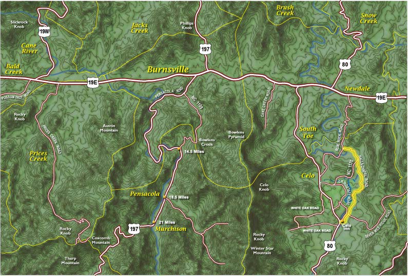 ~ 4 miles
Exit Celo Inn., L to cross bridge – L onto Seven Mile Ridge Rd – (.3) L on Halls Chapel Road and ride end to end. Few hills, almost no traffic and is quite lovely. Great views of Black Mountains and South Toe River. Double back to Celo Inn for a sweet 8 mile ride. Short to medium length ride.
Celo Route #2
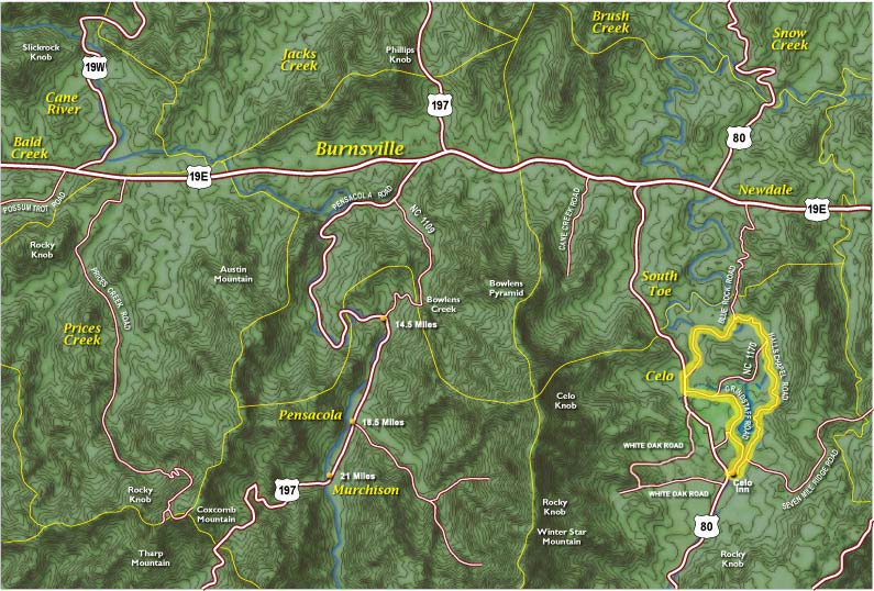 The Local 9 ~ 9 miles
Exit Celo Inn, L to cross bridge – L onto Seven Mile Ridge Rd. – (.3) L onto Halls Chapel Rd. – (4.4) L onto Blue Rock Rd. – (5.5) L to cross bridge (S. Toe River) – (6.4) L onto Hwy 80 – (6.8) L onto Lower Browns Creek Rd. – (7.3) R onto Grindstaff Rd. – (9.5) L onto Hwy 80 – (9.58) L onto Seven Mile Ridge Rd. – L into Celo Inn parking lot
Medium length ride
Celo Route #3
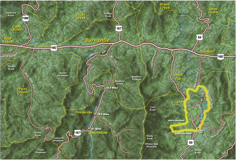 The Local 11 ~ 11 miles
Exit Celo Inn., L to cross bridge – L onto Seven Mile Ridge Rd – (.3) L on Halls Chapel Rd. – (4.4) L on Blue Rock Rd. – (5.5) L to cross bridge (S. Toe River) – (6.4) L on Hwy 80 (7.5) R on Upper White Oak Ck. Rd – (10.7) L on Hwy 80 – (10.9) R on Seven Mile Ridge – L into Celo Inn parking lot
Medium length ride.
blank
Pensacola Ride #1
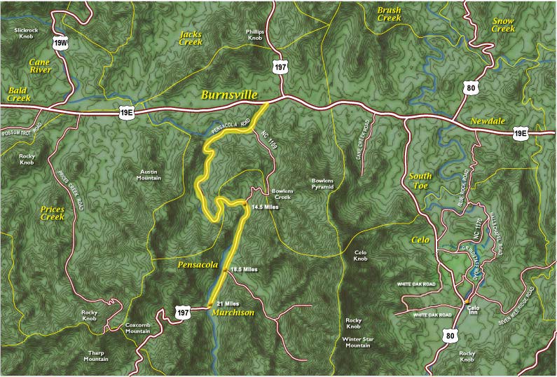 Park at the Texaco on the corner of 19-E and 197-S or at Brookside Rehab ~1/2 mile south on 197 Follow 197 to Murchison and return.
Medium to long length ride.
Pensacola Ride #2
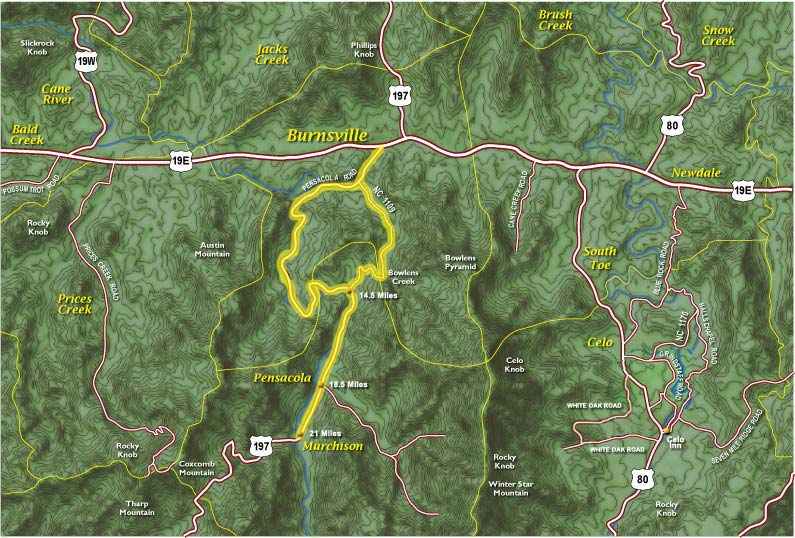 Park at the Texaco on the corner of 19-E and 197-S or at Brookside Rehab ~1/2 mile south on 197 Follow 197 to Murchison Turn around and after passing Cattail Creek Road turn right on Bolens Creek Rd which climbs and then descends dramatically along Bolens Creek to rejoin 197 just south of Brookside Rehab . Medium to long length ride
 Pensacola Ride #3
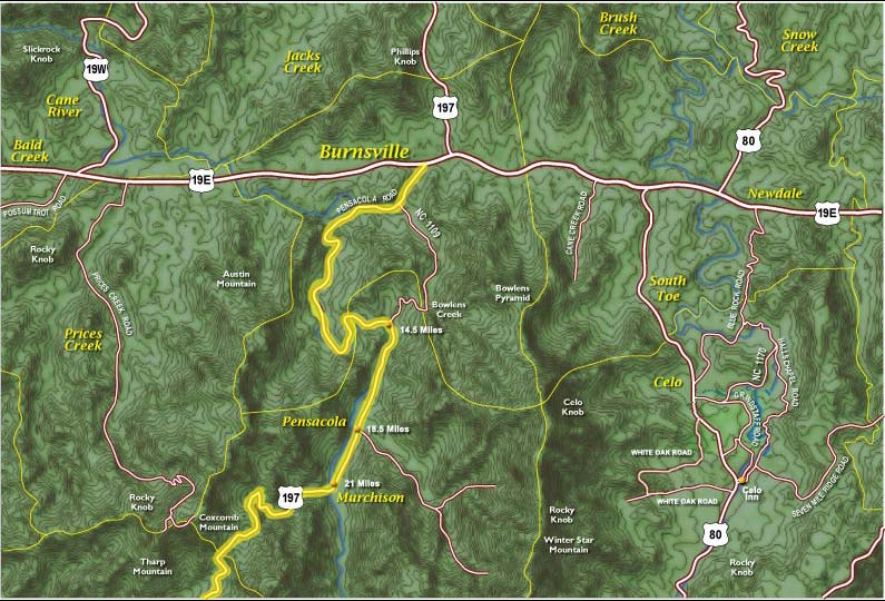 Follow 197 to Murchison and JUST KEEP GOING The pavement has been extended to the county line at the top of the mountain. The climb is well-graded and never punishing steep. Back the way you came—UNLESS—you are on a mountain bike in which case you could fly down the gravel Buncombe County side into Barnardsville. Long length ride.
![]()
hiking trails maps
![]()
walking guides
art scavenger hunt
This scavenger hunt provides an overview of public art along Burnsville’s downtown. Begin the hunt at the town square. During your search, take pictures of the works and share them on our Facebook page. HAPPY HUNTING!
history scavenger hunt
This scavenger hunt explores Burnsville’s history, art, and other elements of downtown. Begin the hunt at the town square. During your search, feel free to take pictures of your finds and share them on your favorite social media site. HAPPY HUNTING!